Navigatie en GPS.
Iedereen rijdt al zo'n beetje met een Tomtom in z'n auto. Maar voor verre reizen heb je toch meer een GPS apparaat nodig waar je zelf verschillende kaarten op kunt zetten. Naast de GPS (wij hebben een Garmin e-trex Vista HCX, klein, compact, waterdicht, 24 uur op 2 AA batterijen en kleurenkaart) hebben we als backup een telefoon mee. Een smart-one, met GPS erin (wij hebben de Samsung Omnia II i8000 gekozen omdat daar de batterij het lang van uit houdt).
Hierop hebben we kaarten van Garmin zelf staan bv CN (City Navigator NT) Europa 2011 of nu dus CN 2012 en de openfietskaarten of CN Iran (Jawel, hier free gratis download van Garmin Iran Map, is een Gmapprom.img file dat je vervangt voor diegene die er al staat of erbij plaatsen als je apparaat dat aan kan), Tracks4Africa (versie 10.10 is al uit) natuurlijk voor Afrika (erg handig!) en downloads (handigste GPS link) van Openstreetmaps. Wij gebruiken in Azië de world routable garmin maps. Op deze laatste pagina vink je Reset Selection aan en vervolgens welke kaarten je wilt. Email adres invullen en je krijgt de gps-map in verschillende vormen toegestuurd. Uploaden en klaar!
De wereld van de telefoons en navigatie apparaten veranderd snel, net zoals de beschikbaarheid van gedetailleerde nieuwe kaarten. 3 Dimensionaal is de trend.... Kijk zelf wat je nodig hebt.
De Vista GPS bevalt goed. We gebruiken hem in Nederland ook, dan staat de CN map transparant over de topografische kaart voor erg veel detail.
Hij heeft geen gesproken stem voor navigatie-aanwijzingen en als het achter de voorruit warm wordt laat het rubberen seal rondom het apparaat los. Maar ook dan blijft ie waterdicht en goed werken. Hij klikt in een houder, we hebben er zo'n 3 voorin de auto. Onder een drinkbekerhouder vlak voor de bestuurder, als de auto geparkeerd staat valt het niet op... Op de handgreep steun boven het dashboard kastje zit een fietshouderklem, voor als de bijrijder goed zicht wil hebben. En we hebben een Beanbag, erg handig op te stuiterende wegen. Het klemmetje waarmee het gps-apparaat vast in een houder klikt is wel gevoelig en breekt bij ons 2x af.
Alle GPS apparatuur (Garmin outdoor's of Magellan's) kun je op de laptop aansluiten en zo je route etc. bij houden of zelfs op groot scherm op je laptop zien waar je rijdt. Software hiervoor is bv. Mapsource (ook gratis download MS voor Garmin zonder CD of DVD installatie!), Basecamp de modernere versie van Mapsource (ook zo op je laptop PC te zetten), Touratech of Ozi-explorer. In de laatste kun je ook nog zelf kaarten inscannen en gebruiken. Zelf heb ik hier inmiddels een grote data base van de hele wereld van opgebouwd, die ik graag met je deel. Incl. de Russische stafkaarten.
Onze route GPS kaarten die interactief zijn omdat je onze route en waypoints op verschillende achtergrond kaarten kunt zien, kunt inzoomen tot groot detail etc. hebben wij gemaakt met GPS Visualizer. Werkt makkelijk. Kortweg: Je track en waypoints uploaden, opslaan als .html bestand en een API code die je bij Google voor de Google maps ophaalt invullen op de juiste plek (achter: var google_api_key = ''; tussen de ' ' ) en uploaden naar je website.
Verder is er veel informatie over GPS vindbaar op internet. Zie bv:
GPS info
GPS forum
GPS tracks
GPS vragen
GPS informatie
Nog een idee om persoonlijk antwoord te krijgen op je vragen is langs gaan bij de GPS vraagbaak. Wim geeft ook cursus... maar die zijn er overal wel. Let wel op het nivo wat bij je past!
Als je bang bent om je tas kwijt te raken, of met je hond ergens vrij rondloopt, hier onder enkele links naar bv een GPS tracker of de Garmin Astro 220 met halsband DC 20, 30, 40 waarmee je tot elf kilometer in de buurt je hond kunt blijven volgen! Natuurlijk voor veel meer toepassingen te gebruiken.
Kost incl € 699,95 en werkt op batterijtjes AA.
http://www8.garmin.com/astro/
en https://buy.garmin.com/shop/shop.do?pID=8576&ra=true
of http://www.gundogsupply.com/garmin-astro.html of simpeler: http://www.gundogsupply.com/garmin-gtu-10-gps-locator.html danwel: http://www.pocketnavigation.nl/news/view_552__de-gtu-10-gps-tracker-van-garmin/3.7.1.html
Dit is ook een NL systeem maar levert nog steeds niet: GPS halsband voor de kat http://www.navibel.nl/index.php?page=Navibel
Dus handige systemen die mbv GPS uw huisdier of tas bewaken en blijven volgen, zelfs de route vastleggen van uw hond of kat of tas of auto !
Trouwens in ieder geval ook te koop bij globetrotter.
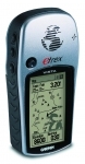
Garmin eTrex Vista HCX
Deze gebruiken we op het moment met plezier !!
Handheld GPS, High Sensitive Receiver, Micro SD Card slot, Altimeter, Electronic Compass
Overview
The Garmin Vista HCx, brings a high sensitive receiver to Garmin's popular line of eTrex handheld units. It features a small GPS receiver and navigator with a color screen you can hold right in your hand. The Vista HCx is modeled after the original eTrex Vista, the color Vista C and the Vista Cx, which brought expandable memory to the eTrex series. Now it has a high sensitive receiver, although unlike other previous Garmin units, the high sensitive receiver chip is not a Sirf product, rather a MediaTek 3. Designed for outdoor use, such as on the trail, hiking, geocaching, and biking, the HCx also can be used for highway use, if you purchase the Garmin CityNavigator maps. Overall, the unit operates nearly identical to the Vista Cx, with just a few minor changes. The only feature change in the HCx is the ability to customize the routing color. The Vista HCx lists on the street for $299. In Europe more expensive because of the WorldBaseMap. Check discount prices here. Also in Europe now cheaper because it already longer on the market now. Garmin has also upgraded its line of eTrex models with color screens and the high sensitive receiver, including the eTrex Summit HC, which includes an electronic compass and altimeter, the eTrex Venture HC, which does not have a card slot, but a limited amount of internal memory and does not have the ability to give road navigation, and the eTrex Legend HCx, which is identical to the Vista HCx, except the Legend does not have the electronic compass or altimeter.
The Unit
The Vista HCx is the same size as its color model predecessors. It has a color screen, a power/backlight key, a page key, map zoom in and out keys, the find key and the joystick key. While there is a card slot, no micro SD card is included in the unit package. I have used a 1GB card without any problem and you can find a 1GB micro SD card for around $25. This provides more than plenty of room for maps. Included in the Vista HCx package is the unit itself, loaded with a basic basemap, wrist strap, owners manual, a USB cable for computer use and MapSource Trip and Waypoint manager, which allows you to connect the HCx to a computer and manage your waypoints, routes and tracks. It contains a similar basemap that is loaded in your unit and does not have any specific map detail.
Features
The most important key on the Vista HCx is the page key, which is on the upper right hand side. This is how you bring up the different function pages, which are summarized below. I have found the best way to get acquainted with the unit, is to press the menu key on every page and you will usually find more features and functions that the HCx has the capability to do. Here is a photo of keys, starting on the right and going clockwise:
(Right Side)
Page/Quit Key
Power/Backlight Key
(Left Side)
Zoom Out
Zoom in
Joystick Key (Front of unit)
Find/Menu Key
Satellite Page
This will show you the status of the satellites. It will show if it has a satellite lock by giving the lat/long. Pressing menu will allow you to use the unit indoors by turning the GPS function off, north or track up, blue satellite icons or multi-color, new location,-- which puts the unit into locating satellites mode if you have moved hundreds of miles from the last use and GPS elevation. This pages also shows you the elevation, but according to the GPS satellites, not the altimeter.
Satellite page shows accuracy, current latitude and longitude and location of satellites in the sky and which satellites are receiving signal. 'D' indicates the unit is getting WAAS correction from a WAAS satellite, in this case, #49.
Map
This is the map page, and this shows optional CityNavigator detail. The black triangle represents my position. The data fields, which here show speed and elevation are customizable and also allow two additional data fields, but this will reduce the size of the map that is visible. (A screen example of the optional TOPO 2008 software is shown later on in this article when tracks are discussed.)
Routes
When you create an active autoroute with the optional CityNavigator map detail, it will give you step by step directions to your destination. You can show times to go, or actual estimated arrival times to each leg of your route.
Compass
This is for getting to a location off road. It is not an actual compass, but works from determining your movement. This is until you turn the electronic compass on and your speed is less than five miles per hour, which will activate the electronic compass. You can also customize the data files on this page by pressing 'menu.' Remember to press and hold the page key to turn the electronic compass on/off.
This view shows that I am heading directly west here and the red arrow indicates the direction of my destination. The data fields show I am 129 miles away, this is as a crow files. It also gives an ETA, based on my distance and current speed. The numbers on the compass icon, indicate the heading. For example from this screen shot I am heading 270 degrees, while my destination is at about 290 degrees, as each line represents ten degrees.
Altimeter
This is the built in barometric altimeter page. You can calibrate the altimeter on this page by pressing 'menu.' You will then be prompted for either the current barometer pressure or you must know your current elevation. You can also use the joystick key and adjust the scale of the altimeter. Also using the joystick key, you can use the red crosshairs that will appear, to move back and see your altitude. It will also bring up the date and time of this location. And when you press the joystick button in, it will bring up the map page and show your location on the map of where you were at, at the altitude you selected. For example, if you hike a summit and want to see where it was on the map, you can go to the peak on the altimeter and bring up the map page. This is discussed in more detail just below in the 'Tracks' section of this article.
Main Menu
This allows you access to the setup page, as well as mark, find, and the following other features included in the unit.
Tracks
One of my favorite features in a GPS is the ability to be able to log tracks, which means the VistaHCx will record your lat/long, speed, heading, elevation, and time, providing a way for you to download it into your computer to analyze and to save tracks so they are visible on the GPS for future reference.
This screen shows a saved track, which you can name and customize the color that it will appear on. You can also use 'TracBack' which is a feature to help you follow the 'breadcrumb' trail you have created.
This screen, with TOPO 2008 data, shows what a saved track looks like on the map page. The red line is a trail I hiked to get to a waypoint. I have saved it so it always shows up on the map. You can save a track and manually select where you want it to start and where you want it to end. If it is more than 500- points it will be condensed down to that size. You can also do a lot with tracks using the included MapSource Trip and Waypoint manager, for editing, saving, etc and then sending the track back into your GPS. You can save a total of 20 tracks in your Vista HCx.
This is the profile screen, that you can bring up by pressing 'menu' while on a 'saved track' page. Note the red cross hairs are movable and when you press down on the joystick key, you will bring up the location on the map page. See image below for example.
Cursor shows where the actual location is from the profile page. Note the two saved tracks visible on this page, the red and the light green, which follows the road on the map. You can also see two waypoint locations on this page. (Round Knoll and Tent) This is similar to what you can also do on the altimeter page.
Other Features
The Vista HCx has a few other features not directly related to GPS navigation.
Sun & Moon
This page allows you to get the readout of sunrise, sunset, moonrise and moonset. You can adjust this by date, if you want to know sunset a month from now. You can also find the sunrise/sunset for another location, by selecting 'location' and then using the find key to bring up the location you want to use.
Hunt & Fish
This uses the celestial tables to calculate a prediction for wildlife activity. You can also change the date and location for a reading, similar to the sun/moon table.
Games
There are a few games you can try. Some are actually for use outside and require you to physically move around and it relies on gps signal to work. Others are simple games you can play while sitting down and have nothing to do with gps.
Stopwatch
The stopwatch allows you to calculate laps, by either distance or manual use.
Calculator
This is a standard calculator and also has scientific calculator abilities.
Calendar
The calendar lists sunrise/sunset, as well as icons representing hunt/fish predictions. You can save a waypoint in the calendar and it also stores waypoints in the calendar when they are saved. (This data is lost if you delete the waypoint however)
Highway
This is the highway page, which gives you a layout of your route. It is somewhat of a 3-D view, and you can zoom it in and out, however there is no other detail visible besides the purple route line.
Settings
Like all of the eTrex models, you can customize many fields, the screen colors and the tones. I have found this to be an excellent feature so you can make your unit operate the way you like it. Here is a summary of your options:
System
This page allows you to select the GPS mode you want, from normal, to demo mode, to battery saver. You can also enable or disable WAAS, select the battery type, between alkaline or NiMH, the language, including English, French, Spanish or Portguese. This is also where you can enable the proximity alerts and pressing menu will allow you to look at the software version of the unit and also the high sensitive receiver software. You can also bring up the card info page, to see how much space you have left on your memory card, and what percentage is for maps, saved tracklogs and Custom POI's.
Display
Display allows you to select between the daytime (bright look) and nighttime, (reverse look) and if it should automatically switch between sunset and sunrise, which is the default. You can also select different color schemes here to customize the look of the screen and set how long you want the backlight to stay on. The default for this is 15 seconds, to help preserve battery life.
Interface
This allows you to connect your unit as a Mass Storage Device, to transfer tracklogs which are saved to the micro SD card. You must use your computer to stop the device and your Vista HCx will automatically restart in a GPS mode. There are no options for any NMEA data or other format through the interface, except for the Garmin protocol.
Tones
You can customize the tone sounds and turn them off, for a message, pressing a key, powering the unit, and turn alerts while using the autorouting feature. You can also specify tones for the proximity alerts.
Page Sequence
This is a nice feature, which allows you the option of only selecting which pages you want and which order. For example, I have my unit set up with the satellite page first, followed by the map page, the compass page, the altimeter and the main menu. You can add pages, use fewer or change the order to which you prefer. You can also access any page from the main menu, even if it is not in your page sequence.
Routing
This allows you to customize between following the road (if you have City Navigator Maps or use the basic basemap included in the unit) or off road, which gives you a direct as a crow flies line to your destination. When autorouting on roads, you can select between Faster Time and Shorter Distance. The 'faster time' will use freeways and highways, where speeds are higher, while 'shorter distance' will create the shortest possible route. Routing Color setup is a new feature in the HCx and allows you to select the color of the active route, instead of the magenta which has been the only option in previous eTrex models. Follow Road Options allows you to select the type of route calculation, from quick calculation to best route as well as car/motorcycle, bicycle, pedestrian, etc. You can also avoid U-turns, toll roads, car pool lanes, etc.
Image of a pop up screen which shows you the upcoming turn, including distance, time until turn and the green line indicates the planned route.
Geocache
You can set up the icons for geocaching and whether you want the calendar to store the date of when you found a specific geocache.
Marine
The marine function allows you to set up a drag alarm, which will sound if you drift from the user specified distance. You can also get an alarm if you stray from the course or direction you are heading. Both distances are user specified.
Time
You must specify which time zone you are in, it does not automatically update it for you. You can also select between 12 and 24 hour time and if you want the unit to automatically update for Daylight Savings time. The HCx units have been programmed to handle the new dates of the spring and fall time changes.
Units
You can customize the lat/long format, the map datum, WGS 84 is default, between English and Metric, Statute and Nautical, and barometer settings.
Heading
Allows you to specify if you want Cardinal Letters, (N, E, S, W) or numerical degrees, as well as the North reference, between True North, Magnetic, etc.
Calibration
This is where you can calibrate the compass and altimeter in the VistaHCx model. You can also calibrate each sensor on the compass and altimeter page as well.
Altimeter Setup
You can select if you want the unti to autocalibrate the altimeter, which means it will take the GPS altitude to keep the altimeter in an approximate range. You can also calibrate the altimeter here if you know the current pressure or the altitude of your location.
Welcome Message
You can setup the opening screen, with your name, phone number, address, etc, to help your unit get returned to you if it becomes lost.
Jumpmaster
This is feature to assist you in skydiving or parachuting out of airplanes. Since skydiving is not a hobby of mine, please consult the Garmin page on this here, if you want to know more about Jumpmaster.
Satellite Acquisition
The Vista HCx does a great job locking in satellites with the new high sensitive receiver and its built in patch antenna. The initial find was very fast and in my house it has no problem getting a satellite lock. A cold start is usually about 30- seconds and a warm start (when the unit has been on in the last hour) can be in less than ten seconds. I have noticed significant improvement compared to my VistaCx in getting a satellite lock and then keeping a satellite lock. I have used the HCx on a commercial airline and after holding the unit up to the window to get a satellite lock, was able to place the unit on the pull down tray and keep a satellite lock. In comparison with my 60CSx it seems to work about the same, from my own observation. In canyons and the mountains it works great, the only satellite issue I found is mentioned below in "Areas for improvement."
USB Power
When you connect the HCx to the computer through the USB, it will power the unit. You can also power it through an optional Garmin USB DC power cable. There are both AC and DC type adapters available from Garmin as additional accessories.
POI Loader
The Vista HCx is compatible with Garmin's POI loader. You can add custom Points of Interest into the unit. So far, I have loaded 38,000 POI's into the Vista HCx. You can read more on custom POI's, by following this link on gpsinformation.net. You can also select the type of alert you want. You can also set proximity radius in your waypoints. For example if you want to be alerted if you get within one mile of a certain waypoint or want to stay away from something else and be alerted if you get too close, use a proximity alert, which is located in the main menu.
This shows a Custom POI file which contains all of the Major League Ballparks. I can select anyone and will be prompted to either map it, go to it, (navigating a waypoint) or I can actually save it as a new waypoint.
Map of POI with icon loaded into the Vista HCx through the POI Loader. Shown with optional CityNavigator map data loaded in the Vista HCx.
Tracklog Memory
The Vista HCx has the ability to save tracklogs onto the memory card. The HCx records up to 10,000 tracklog points. But in the tracklog setup, you can save all of your tracklogs by selecting 'data card setup' which gives you the option of checking "Log Track to Data Card" and lists all of the tracklogs, by date, for example "20070902.gpx" represents September 2, 2007. The files are created as .gpx, which is compatible with many programs, including MapSource. There is also a readout of how much memory is left on the card. You also have the option to delete all the track log files, or you can highlight one specific file to delete it. You can also select "USB Mass Storage" in the Interface option of the Setup menu and the unit will actually go into USB mode, until you "safely remove it" on your computer. The card will show up like any other removable data card on your computer. You can open up the .gpx files in MapSource, G7toWin, Easy GPS, or other programs that will read the .gpx format. When you are finished and "safely remove the card", the Vista HCx will automatically restart, as it would if you turned it off and back on. Each tracklog file size varies, depending on how many track points are recorded. Typically they are about 60KB, but if I do a lot of driving I have seen them as high as 150KB a day. One issue I have discovered is that if you save more than 50 days worth of tracklogs on the data card, it will only show the first 50. However, if you connect the unit or the card to a computer, you will find that all of the tracklog files are there, even though your most recent ones are not visible. But again, you can only delete the tracklog files on the display, so it is not necessary to see the newest track files on the screen, to get access to them, only if you wish to delete them. And you of course can delete them when your GPS is connected via the USB to the computer.
This screen shows what to select to get access to tracklogs saved to the data card. The checkmark at the top must be enabled to save the tracks to the microSD card. The Green and 62% indicates how much total card memory is occupied by maps, custom POI files and saved tracklogs.
Marine Points
Unlike the VistaC and Cx, the Tide Station data is not included in the HCx model. However if you load in TOPO 2008 software for the specific area of the ocean you plan to visit, it will include the Tide Station data under Marine.
Battery Life
Garmin says the average battery life in the Vista HCx is 25 hours. Using WAAS will reduce this some as well as extensive use of the backlight and enabling the compass. There is also the option of using NimH and Lithium, which can be changed in Setup, under "System." I believe the battery life under normal use is closer to 18-20 hours from my experience.
Hardware Features
The VistaHCx is a rugged unit and can handle the basic conditions of the outdoors. It is 4.2 inches long, 2.2 inches wide and 1.2 inches thick. The screen size is 1.7 inches by 1.3 inches. With two AA batteries, the unit weighs 5.5 ounces. The display is a 256 color TFT and is 176x200 pixels.
USB Connection
To connect the Vista HCx to transfer data, connect it to the USB port on the rear of the unit. The Vista HCx acts as a "Mass Storage Device" and this means that the first time you connect it to your computer, it will have to recognize the Vista HCx and install it. If you use it in USB mode, you must disconnect it ("Safely Remove Hardware") from your computer. However if you use it in Garmin mode for MapSource, WebUpdater, POI Loader, xImage, this is not necessary.
Backlight
There is a backlight available. and you can vary the length it remains on and the brightness level. You can also adjust the level by a quick press of the power key and using the slider to adjust it to the level you want.
Screenshots
The Vista HCx is compatible with xImage, which allows you to grab screen images, including those in this article. You can also create custom waypoints symbols and send them to the VistaHCx as you can with other Garmin handheld units. For a link to xImage from garmin.com, click here.
External Antenna Jack
There is no external antenna options on the eTrex series, although since this is a handheld unit along with the high sensitive receiver this should not be an issue.
Software Updates
Garmin has made some improvements to the VistaHCx during our testing, including upgrading the GPS chipset, issues regarding failure to properly calculate distance with the odometer and a few other issues. We suggest you make sure you have the latest unit software, available for free from garmin.com. Use Garmin's WebUpdater or follow this link.
Questions:
Is there 3-D map view capability with the VistaHCx?
No, all map views are the traditional flat, 2-D view only.
Can I get a latitude / longitude reading and altitude information.
Yes, by accessing the satellite page.
Is the Vista HCx waterproof?
Yes, to IPX7 standards, which means in one meter of water for up to 30 minutes.
Is there NMEA in/out data capability?
No.
Is there a card slot for additional memory?
Yes, there is a micro SD card slot for additional memory, although no card is included with the unit. The Vista HCx comes preprogrammed with only a basemap.
Is the unit powered when connected to the computer via the USB connection?
Yes, the Vista HCx is powered when connected to the USB port, which is for data exchange.
Areas for Improvement
As of software version 2.40, which was released in September of 2007, it seems all of the problems with the initial release of the Vista HCx have been fixed except for one. I have noticed on several occasions that when you attempt to get a satellite fix in a downtown area, canyon or when the unit is in 'locating satellites' mode there is a big issue. What happens is that the unit will struggle to get a satellite lock and when it does, the unit will not correctly show your location and give you an incorrect lat/long and show the wrong location for where you are actually at. This is usually off by more than a thousand feet. The best indication that this is problem is happening is that the GPS accuracy on the satellite page will be a higher number than usual, somewhere between 60 and 100 feet and not go down to the normal range of 10-20 feet accuracy. The problem is that if you don't know where you are at, you will be led to believe you are somewhere you are not. I have discovered a simple fix to this issue is to simply turn off the unit and power it back up again. It should get a satellite lock very quickly and upon restarting, have an accurate lat/long. This is a problem which we hope Garmin will remedy in a future software update. Another improvement would be on the owner's manual. The manual is much briefer than it could be and I think it should be. While Garmin appears to be keeping it simple, there are functions that users may not know exist, except to find them on their own. You can download the Vista HCx manual from garmin.com to look it over for yourself by following this link.
Summary
The VistaHCx seems to have brought the eTrex series to full features currently available in a handheld outdoor unit, which is also capable of routing on highways. It is also similar in features to the Garmin 60CSx, which has a bigger screen and different shape as well as quad helix antenna. Having used all of the etrex models that have evolved into this one, I have found the HCx is a handy small GPS unit, with all of the features that seem to be on the market right now. I would say it is best suited for geocaching and outdoor use such as hiking, etc. It does well with road navigation if you purchase the CityNavigator software, however it not as easy to operate in a car as the touchscreen navigators and the VistaHCx does not offer any voice directions, only an audible alert when to turn. What I like about the VistaHCx is the small size, and I don't feel like I am giving up any features.
We used this GPS during our trip and life (also it functions for us like a TomTom at home) and we like it. Only problem is that in the car by higher temperatures behind the windowscreen the rubber around the GPS loosens. It’s getting then also a bit sticky. Garmin serviced it, but it stays the same.
Nowadays there also more flashy GPS’s around, like the Colorado.